Revolutionary War Sites in Bergen County
Allendale
The Fell House
475 Franklin Turnpike
Allendale, N.J. 07401
201.783.8754
Originally called “Peterfield” this mid 18th century mansion was the home of John Fell, Bergen County Revolutionary War patriot and member of the First Continental Congress of the United States. Fell was a merchant who before the Revolution had vessels plying the Hackensack and Passaic Rivers. He served the county as a Justice of Peace and a judge of the Court of Common Pleas. As a member of the First Continental Congress of the United States, Fell ratified the Constitution. During the revolution he had a reputation as a “great Tory hunter” and on April 22, 1777 was taken prisoner at his home by a band of 25 Loyalist raiders and imprisoned in New York City. Fell was paroled on January 7, 1778 and permitted to go home on May 11. Fell kept a diary while he was a member of the Congress for the State of New Jersey from November 6, 1778 to November 30, 1779. The original is kept in the Library of Congress. Open for special events.
Alpine
Closter Dock Rd.and Old Dock Rd.
Closter Dock Road was a major route from the town that led up over the cliffs of the Palisades down to the Closter Docks on the Hudson River (now Alpine Landing). This became a busy commercial boat and ferry landing during the 18th century. During the Revolutionary War it was used was used by military troops who fought on both sides of the war. There is a historic marker in front of the Alpine Community Church at 5 Dock Rd. explaining the road's history.
Kearney House
Palisades Interstate Park
Alpine Approach Rd.
http://www.njpalisades.org/kearney.html
201.768.1360 x108
The 18th century historic Kearney House, known also as the “Blackledge-Kearney House,” contains exhibits and holds public events that reflect Hudson River life. On November 20, 1776, British General Cornwallis’ army began landing in force, having crossed in the early morning from NYC with an army of 5000. An old marker near here shows that it was once believed they landed at this spot, leading to the Kearny House, for many years, to be mistakenly called “Cornwallis Headquarters.” Although some troops may have climbed up the Palisades at this site, extensive research by Cresskill Historian John Spring, leading up to the Bicentennial in 1976, showed that the British soldiers and Hessians came ashore over 1½ miles south of this point at what is called “Huyler’s Landing” or “Lower Closter Landing.” The British began climbing the steep trails of the Palisades before marching 6 miles south to attack Fort Lee (then known as Fort Constitution). A new interpretive marker “Untangling Folklore from Fact” was erected by the PIP in 2009. For additional historic information: www.njpalisades.org/cn1998_11.htm
Bergenfield
South Church
150 West Church St
Sometimes called the South Schraalenburgh Church, this congregation was founded as a Dutch Reformed Church in 1723 in the area of Bergen County called “Schraalenburgh,” which included Bergenfield and Dumont. Many members of the church during the Revolutionary War were Patriots while others were Tories. The South Church’s historic cemetery contains the burials of Revolutionary War soldiers. The current church building was built in 1799 and is listed on the National Register of Historic Places.
Closter
Naugle/Auryansen Cemetery
Hickory Ave.
This historic cemetery on land purchased by the Naugle Brothers in 1710, contains the burials of seven Revolutionary War soldiers - who were also local Closter farmers - who served in the Bergen County Militia. Some of the earliest Dutch pioneer families are buried here including Auryansen, Demarest, Durie, Haring, Kearney, Naugle, Parsells, Vervalen. Many of their sandstone and frame houses can still be seen in the borough today, including the Naugle House on Harvard Street which was owned by David Naugle, a Bergen County militiaman during the Revolutionary War.
Demarest
Sautjes Tave's Begraven Ground Cemetery
Bogert Rd. and Everett Rd.
www.demarestnj.net/History.php
This small cemetery dates back to the Revolutionary War and contains a number of patriots of the American Revolution War. One noted historic marker reads: "Here lies the remains of Douwe Talema, who died on the 11th day of May 1779 in his Ninetieth Year. This aged Man at his Residence near this Place was willfully and barbarously murdered by a Party of Tories. Traitors to their country who had taken refuge with the Troops of Britain then in New York and came thence to murder and plunder. To pay a Tribute of Respect to his memory and also to commemorate the manner of his death, several of his relatives have erected this Stone."
Dumont
Old North Church and Cemetery
120 Washington Ave.
This historic Dutch Reformed church was organized in 1723 as the Shraalenburgh Reformed Dutch Church. Its first church building was built in 1728 and the present was built in 1801. Its churchyard is the resting place of many Revolutionary War soldiers. One of the finest examples of early American church architecture, the building is listed on the National Register of Historic Places.
Derick Banta House
Dumont Public Library (Dixon Homestead Library)
108 Washington Ave.
http://dumont.bccls.org
The original house - now the Dumont Public Library - was built by Derick Banta, a Revolutionary War soldier, between 1780 and 1790 replacing the house of his birthplace which had been burned by Tories.
Edgewater
Burdett's Landing Site
Annett Ave.
A plaque marks the road that leads to the site on the Hudson River of Peter Burdett’s ferry, which during the Revolutionary War was a strategic approach to General Nathaniel Greene’s encampment on the hill at Fort Constitution (Fort Lee) on the hill above. Burdette was a New York merchant who bought 400 acres near Edgewater in 1756 and founded a trading post and ferry service, transporting goods and people on the Hudson River from New Jersey across to New York. During the war, the landing played a role in the movement of American supplies and soldiers. A memorial near the river recalls the engagements of August 18, October 8, 9, and 27, 1776, between General Mercer’s shore battery of eighteen-pounders and British war ships.
Englewood
Liberty Pole
Corner of Lafayette & West Palisades Avenues
Local folks raised Liberty Poles, a public symbol of American defiance, to celebrate the repeal of the Stamp Act in 1766. One of the first Liberty Poles was erected here, near the original site of the 18th century Liberty Pole Tavern. The tavern was the center of political and social activity and gave name to the surrounding area. This strategic junction was the scene of many American and British troop movements, including the 1776 retreat of the Continental Army from Fort Lee, and British activity in 1776 and 1778.
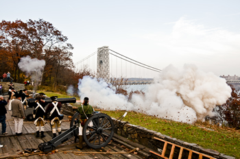
Fort Lee:
Fort Lee Historic Park
Palisades Interstate Park
Hudson Terrace
http://www.njpalisades.org/fortlee.html
201.461.1776
Located on the cliffs overlooking the Hudson River with spectacular views of the George Washington Bridge, Fort Lee played significant part in America’s fight for independence when General Washington and his Continental Army, who were stationed here, were driven out by the advancing British army on November 20, 1776. It was the beginning of NJ’s role as the “Crossroads of the American Revolution.” The Visitor Center provided information on the role of Fort Lee in the American Revolution with two floors of displays that tell the story of the tumultuous New York campaign of the fall of 1776—culminating in the Continental Army’s "Retreat to Victory" across the Jerseys. Events are held here throughout the year and visitors can walk the paths and enjoy the scenic views of the Hudson River.
Monument Park
Palisade Ave. and Monument Place
Monument Park was built and dedicated by the Daughters of the American Revolution in 1908. The location of the park was part of the original Fort Constitution, where the Continental Army was stationed in 1776. The centerpiece of the park is the majestic “Rebelmen” statue. In addition to this statue, there are plaques at each corner of the park. Individual plaques are dedicated to Revolutionary War Generals Horatio Gates, Henry Knox, Hugh Mercer, and Nathaniel Greene; and one to Thomas Paine. Open from 8 a.m. - 7 p.m., and 8 a.m. - 10 p.m. during daylight savings time
Bergen County Retreat Route Signs
These signs run from Fort Lee Historic Park to Acquackanonk Bridge in Wallington and mark the retreat route taken by General Washington’s Continental Army after the invasion of the British troops who crossed the Hudson River on November 20, 1776. See “Revolutionary War in NJ” website below for link to map of signs.
Garfield
Post Ford Monument
River Rd. and Columbus Ave.
During the retreat from Fort Lee, George Washington and his army passed this way before crossing the Passaic at Acquackanonk Bridge on November 26, 1776. There is a five-foot tall fieldstone monument on a small rise that juts out into the Passaic River. It is best to park on Columbus Avenue, and then walk across River Road to see the monument. If you walk beyond the monument, a short walking path will take you to a scenic view of the river.
Hackensack
The Hackensack Green
Bounded by: Court St. (south), Main St. (west), Washington Pl. (north) & Moore St. (east)
Hackensack, N.J.
The Green is the historical center of the City of Hackensack, the County Seat. Just north of the Bergen County Court House, it has served as a public meeting place since April 20, 1698 when Capt. John Berry donated the 2¾ acre parcel to the Dutch Reformed Church, which is located just to the east of the Green. In the 18th century the Green was the militia training ground.
Second Bergen County Courthouse
Built in 1734, it was burned to the ground by marauding British and Hessian patrols on the night of March 23, 1780. On the west side of the Green is a historical plaque to mark its location. A temporary courthouse and jail were built in the present town of Oakland to serve for the duration of the war. Beginning in 1783, court was held in Campbell’s Tavern until a new courthouse was constructed on Main Street, at Bridge Street, in 1784.
Archibald Campbell's Tavern Site, 41 Main St. The current red brick building here, erected as the Bank of New York building in 1874, is on the site of the Campbell Tavern of Revolutionary War fame. Campbell supplied meals to General Washington when Peter Zabriskie's home – the Mansion House - was used as military headquarters November 13 - 21, 1776, during the retreat across New Jersey. The army marched down Main Street and camped on the Green during November 20-21, 1776.
Site of the Mansion House, 50 Main St. [PLAQUE]: Torn down in 1945, this was the home of Judge Peter Zabriskie, leading citizen of Hackensack and a staunch patriot. He built a home here in 1751. Enlarged in 1776, the home was called Mansion House, later Mansion Hotel. Zabriskie was one of the driving forces in Bergen County politics and founder of Queen’s College (Rutgers). Washington was a frequent visitor at the house and stayed a night during the retreat of 1776. Washington was there when he heard of the planned attack on Fort Washington in November 1776. He had his headquarters here when the British landed at Lower Closter’s Landing.
Brigadier General Enoch Poor Monument
Moore Street: General Poor was a New Hampshire Brigade commander and one of the heroes of the Battle of Saratoga in the fall of 1777. He fought in the battles of Stillwater, Saratoga, Newton, Monmouth, was at Valley Forge and a confident of Gen. Washington and the Marquis de Lafayette. Poor was in the area because Washington had amassed an army there for a planned attack on New York City which never materialized. He died of fever three years later near Hackensack and was buried in the Church on the Green’s cemetery, which is across the street from the monument. Washington and Lafayette, along with many troops, were among the dignitaries at Poor’s full military funeral.
"Church on the Green"
The First Reformed Church of Hackensack and Cemetery, 42 Court St.:
Organized in 1686, the congregation built the first church building in 1696. The current building was completed in 1792 and is the oldest extant church building in the county. The cemetery contains the graves of many Revolutionary War soldiers and those of the earliest families of the county. The engraved table-monument tombstone marks the burial of General Poor and another large monument marks the grave of Colonel Richard Varick, secretary to Gen. Washington and later mayor of New York.
Ho-Ho-Kus
The Hermitage Museum
335 North Franklin Turnpike
www.TheHermitage.org
201.445.8311
This National Historic Landmark building started out as c. 1760 Dutch sandstone house. During the Revolution the house was owned by Lt. Col. James Marcus Prevost, who died before the Revolution. His widow, Theodosia, liked to entertain influential people, especially military. In July 1778 General George Washington and his troops were traveling through this area. When Washington and his entourage stopped at a local house, Theodosia invited him to stay at her home. He and his officers were entertained at The Hermitage from July 10 to 14, 1778. It is not certain whether he stayed in the house itself or camped on the grounds. Several important pieces of correspondence went out from here during his visit. Among other notable people to visit the house during the war were James Monroe, William Paterson, the Marquis de Lafayette, Alexander Hamilton, Lord Sterling (General William Alexander), Peggy Shippen Arnold, and Aaron Burr. Theodosia eventually married Aaron Burr, at the time a colonel in the Continental Army. The Hermitage is open to the public for guided tours year-round Wednesday through Sunday.
Leonia
Van Horne's Grist Mill Site
Grand Ave., near the corner of Lakeview Ave.
Marker: "Approximately 100 yards to the west once stood Van Horne's Grist Mill as located on Robert Erskine's Map and mentioned in Thomas Paine's 'Crisis' paper. One detachment of the patriot garrison retreating from Fort Lee, left the main body and passed the grist mill on a direct route to Hackensack Nov. 20, 1776."
The passage referred to in Thomas Paine's The Crisis is, "Our first object was to secure the bridge over the Hackensack, which laid up the river between the enemy and us, about six miles from us, and three from them. General Washington arrived in about three-quarters of an hour, and marched at the head of the troops towards the bridge, which place I expected we should have a brush for; however, they did not choose to dispute it with us, and the greatest part of our troops went over the bridge, the rest over the ferry, except some which passed at a mill on a small creek, between the bridge and the ferry, and made their way through some marshy grounds up to the town of Hackensack, and there passed the river."
Dutch Reformed Church of the English Neighborhood Site [MARKER]
Hillside Ave. and Grand Ave.
Marker: “Site of the Dutch Reformed Church of the English Neighborhood built in 1768-9, and dedicated in 1770, with Dominie Garrett Lydecker, its first minister. Used as a guardhouse and hospital at various times during the Revolution. Torn down in 1792, some of the timbers and stone used in construction of the succeeding edifice in Ridgefield".
General Washington Retreat Monument
181 Fort Lee Rd., In front of the Presbyterian Church
Below this relief sculpture by the artist Mahonri Young, the text reads: "On November 20 1776 General George Washington and a part of the Continental Army on their march from Fort Lee to Trenton passed this way. Erected July 4, 1916."
Mahwah
Continental Soldiers Memorial Highway & W3R-NJ Route
Ramapo Valley Road
This road was used by General Washington’s troops during the Revolutionary War. An official W3R – Washington Rochambeau Revolutionary War sign was erected in 2006 recognizing it as the official W3R Route through Mahwah in Bergen County. The W3R signs are positioned above the Continental Soldiers Memorial Highway signs, which were erected in 2000. Similar W3R signs were erected on Island Road, the old King's Highway, in Mahwah which was a secondary W3R route through Bergen County.
In June and July, 1781, after spending the year in Newport, Comte de Rochambeau and his French Army marched through Rhode Island and Connecticut to join Washington’s Army just north of New York City. Then in August word came from Admiral de Grasse that a French fleet, which had been active in the West Indies, was on its way north - but not to New York. He proposed a rendezvous with the allied forces on the Chesapeake where they might intercept Cornwallis, commander of Britain's Southern campaign. Abandoning the idea of attacking the British force in New York City, Washington and Rochambeau embraced the southern campaign strategy - to attack British Lord Cornwallis in Virginia. In August and September, Washington and Rochambeau’s armies marched south through New Jersey, Pennsylvania, Delaware, Maryland, and Virginia for 600 miles, reaching Williamsburg in late September.
Time was short, the distance great, and surprise essential. To maximize its advantage, Rochambeau's army set out from Suffern, New York, on August 25th, on a carefully planned route down the Ramapo Valley, then via the Millstone Valley to Princeton, Trenton, and across the Delaware to arrive in Philadelphia September 3rd. Washington deployed the American forces along a variety of eastern routes, feinting the possibility of an attack on Staten Island, before turning inland to Trenton and Philadelphia.
The ruse worked. Cornwallis was cut off from escape or reinforcement, either by land or sea, at Yorktown. Together, the American and French forces laid siege to the British-fortified town. On October 19, 1781, three week after the siege began, General Cornwallis surrendered to the allies.
Ramapo Valley Road Bridge
Ramapo Valley Rd. at Brakeshoe Pl.
Part of the 1781 W3R route, the marker at the bridge reads: "On August 25, 1781 during the historic 600-mile march to what was the Revolutionary War's decisive Battle of Yorktown, General Rochambeau's army was forced to ford this river because the bridge that was here was in poor shape. The bridge of today was built in 2010."
Oakland
Van Allen House
Oakland Historical Society
Franklin Ave. & Rt. 202
201.405.7726
This National Register historic house was built by the Van Allen family in 1748. The house occupied a strategic position in the area called The Ponds. At the time of the Revolution, the road it was on was one of the six passes which breached the Watchung Mountain chain. It was also near Valley Road (now Rt. 202) one of the most important supply arteries in the colonies. In the summer of 1777, the British General Bourgoyne’s army captured Fort Ticonderoga and the survival of the American northern army was in doubt. Washington quickly left Morristown and headed north on Valley Road. His destination was Suffern, to guard against a move by General Howe toward the American capitol, then in Philadelphia, or a thrust northward to join Bourgoyne. By Monday afternoon, July 14, the Americans had reached The Ponds where Washington called a halt to the day’s march due to the muddy conditions of the roads. Washington established his temporary headquarters that afternoon at the Van Allen house and soon received the word that the American northern army had escaped Ticonderoga and was still in the field. Washington decided to remain at the Van Allen house another day. Now a museum and headquarters of the Oakland Historical Society, it is open for tours and events during the year.
Oradell
Soldier Hill / Lafayette Encampment
Kinderkamack and Soldier Hill Roads
Marker: "The Continental Army advanced to Englewood on August 23, 1780, with some units foraging as far south as Jersey City. The main body of the army moved west of the Hackensack River on September 4th, camping in two lines west of Kinderkamack Road, one atop the ridge and one below. The camp extended from River Edge Road two miles north to the vicinity of Soldier Hill. The artillery park was posted on the heights behind New Bridge in Van Saun County Park. Lafayette had his headquarters at the north end of the encampment, near this spot. The army departed on September 20, 1780.”
Paramus
Washington Spring Garden
Van Saun County Park
County Historic Site
216 Forest Ave.
This scenic, garden setting in the center of Van Saun County Park, surrounds a natural spring that was visited by General George Washington during the Steenrapie Encampment of over 14,000 American troops in these environs from Sept. 4 –20, 1780. This major encampment of troops and artillery stretched for two miles in along Kinderkamack Rd. in area known then as Steenrapie. The army was there as Washington debated an all-out attack of Manhattan. Open during park hours.
Statue of George Washington
George Washington Memorial Park
Paramus Rd. and Century Rd.
www.georgewashingtonmemorialpark.org
Inside this very large cemetery is a very impressive statue of George Washington titled “George Washington Kneeling in Prayer.” It was sculpted by Donald DeLue.
Ridgewood
Old Paramus Reformed Church and Cemetery
660 East Glen Ave.
www.oldparamus.org
Organized in 1725 the first church building was built in 1735. It was a headquarters of General Washington in 1778 and 1780 and used during the war as a barracks, hospital and prison. Noted visitors included Alexander Hamilton, the Marquis de Lafayette, Anthony Wayne, Richard Henry Lee, and Aaron Burr. The current building was finished in 1800 using stones from the original church. In the church’s historic cemetery are the burials of many Revolutionary War veterans.
River Edge
Historic New Bridge Landing
The Steuben House
1201-1209 Main St.
www.bergencountyhistory.org
Historic New Bridge Landing contains the 1752 Steuben House, a State Historic Site and an esteemed Revolutionary War landmark. It was built at this strategic river crossing that served as an encampment, battleground, military headquarters and intelligence-gathering post for the army of General George Washington. In front of the house on the Hackensack Rive is the site of the “Bridge that Saved the Nation” which was used by Washington’s army during the Nov. 20th, 1776 retreat from the invading British forces and which saved him from certain defeat.
According to the Bergen County Historical Society’s website: “… Thomas Paine composed the first tract of The American Crisis - a series of essays intended to rally American resolve during the darkest hours of the war… Published on December 19, 1776, only six days before Washington's victory at Trenton reversed the declining fortunes of the Continental cause, Paine stirred hopes with his immortal refrain: These are the times that try men's souls.”
Gen. Washington used the Steuben House as his headquarters Sept. 4-20, 1780, during the encampment of the Continental Army at Steenrapie (now River Edge). Following the war in 1783 it was confiscated from its owner John Zabriskie and presented to Major General von Steuben. Steuben sold it back to the Zabriskies six years later. One of New Jersey’s most historic houses, it is open during the events of the Bergen County Historical Society which is headquartered on this site.
River Vale
Baylor Massacre Burial Site
County Historic Site
Rivervale Rd. & Red Oak Dr.
This Bergen County-owned wooded park contains the burial site of the 3rd Continental Light Dragoons who on Sept. 28, 1778 were slain during this notorious Revolutionary War event known today as "The Baylor Massacre". On September 28, 1778, British forces under the command of General Charles “No Flint” Grey made a surprise attack on the bivouacked members of the Third Dragoons. They were under the leadership of Colonel George Baylor, a former aide to Washington. There were 67 killed, wounded or taken prisoner. Baylor’s second in command, Major Alexander Clough, a seasoned officer and one of Washington’s intelligence officers, died a few days later from his injuries. Baylor survived but the injuries he received contributed to his death two years later. On October 6, after receiving reports on the tragedy, the Congress (in Philadelphia) decided to investigate and a resolution was passed that New Jersey’s Governor Livingston be directed to inquire into the event. Both Livingston and General Washington requested that Major General Lord Sterling to direct the investigation. Remains of dragoons were found in 1967 during an archaeological excavation. There were later reentered in this park situated along the Hackensack River and is now marked with the sites original millstone. This historic park contains accessible pathways and historic interpretive panels describing the history of the Baylor Massacre. Open during daylight hours.
Wallington
Acquackanonk Bridge
Main St. and Passaic St.
As George Washington and his troops retreated from Fort Lee through the Hackensack Valley, they crossed the Passaic River over the Acquackanonk Bridge on November 21, 1776, and burned it behind them. The army stayed in Passaic, then known as Acquackanonk, for a night before moving south toward Newark